


Cruise Destinations
Oakland Estuary
What's there
The cruise up the estuary affords a bird's eye view of the Oakland port facilities, where huge cranes are often observed loading and unloading cargo container vessels. While passing Alameda Naval Air Station, aircraft may take off and land, roaring close overhead. A variety of water craft teems about. You pass Navy and Coast Guard vessels docked at Alameda, then numerous public marinas. If the return is at night, there are pretty views of San Francisco and Bay Bridge lights.
Cautions
The most easterly safe place to pass under the Bay Bridge is usually considered to be under the first span with an overhead cantilever structure. This leaves the cable crossing structure platform close by on the east. Note that there is a shallow submerged wreck just south of the platform.
On the estuary, particular care should be taken to look behind you occasionally, to verify that monstrously huge vessels are not silently looming up over you.
When sailing to Quinn's Lighthouse, be sure to keep on the proper side of the north channel, as there are some very shallow areas outside the channel.
Management
When sailing to destinations in Alameda County, it is usually convenient to bring the cruise boat(s) around to the clubhouse dock before participants begin meeting at the clubhouse, in order to facilitate getting people aboard for departure.
Winds are usually light on the estuary, but adequate, usually from the west. The return trip, if by sail, would usually involve tacking tediously upwind, and if your crew is not into manning the jib sheets, you may mercifully decide to motor most of the length of the estuary.
Docking on estuary cruises is usually at either the public dock at Jack London Square or at Quinn's Lighthouse restaurant guest dock, though it is also possible to dock at guest docks provided by other restaurants facing on the water.
The public dock at Jack London Square is found easily. It is directly in front of the flagpole with the huge American flag. There is usually no problem finding dock space here, and although the dock has no locked gate, there has never been a problem with anyone tampering with our boats. However, all easily transportable gear should be stowed in the locked cabin. A vast number of restaurants are within easy walking distance from the dock.
Quinn's Lighthouse is about a half hour sail further up the estuary, up the northern channel around Coast Guard Island, on the left side, just short of the very low clearance bridge that crosses the channel. The restaurant building is an old lighthouse that formerly stood at the entrance to the estuary. It is a distinctive square, white, fairly large building, with a cupola on top. A marina area surrounds the guest dock, which is on the distant (west) side of the building. There is usually, but not always, room to dock here. Do not attempt to dock at the dock across the channel at Coast Guard Island, as the military authorities there will menace you with threats to impound your boat. The food and service at Quinn's are quite good, and meals are not exorbitantly expensive.
Ballena Bay
No one hardly ever cruises here. It is a "different" place to go, but not a tremendously interesting one. The principal interest is in passing close by freight vessels anchored in the South Bay anchorage. When I cruised to Ballena Bay in 1986, the marina there allowed us to dock without charge. There was one restaurant in the area, the Whale's Tale. A delicatessen with a small, gardened patio was in the nearby office complex.
Mission Rock
What's there
If this cruise is routed first to the north of Treasure Island, as it usually is, a portion of San Francisco's east waterfront can be explored thereafter, while sailing southward. Our cruises invariably dock at the "relaxed" Mission Rock Resort, a unique weather-beaten terrace restaurant with a view of "industrial strength" scenery, shipyard facilities, south bay waterfront. The food here is relatively cheap and good. On the return trip south of Yerba Buena Island, it is possible to sail in close to the pretty east side of the island.
Cautions
Winds along San Francisco's east waterfront can be exceedingly gusty and changeable. Be careful around the Bay Bridge piers.
This does not make a good night cruise, as the Mission Rock Resort restaurant is closed in the evening.
Management
The most convenient way of managing currents on this cruise seems to be to schedule the departure time near the end of an ebb tide period, so that you can sail with the light ebb around the north end of Treasure Island, and reach the San Francisco east waterfront at the time that the North Bay is ebbing in to flood the South Bay. The return trip will be against the flood tide, but the distance to be covered against strong currents is relatively short, and you will usually be aided by strong afternoon west winds.
The Mission Rock Resort can be difficult to find, if you haven't been there before, or even if you have. You are almost there when you pass the projecting concrete wharf on the east edge of Mission Rock Terminal -- you then have about a half mile to go. When you pass this, start angling in past some dilapidating wooden wharves, into the basin with the large shipyard facility on the south side of it. The "Resort" is a weather-beaten two story building, with some more or less buoyant docks, usually not in particularly good repair, in front of it. It seems to be more or less o.k. to tie up anywhere on these docks, but it might be a good idea to ask around whether you are using someone's rented private dock space. Sometimes a special section of dock is reserved for guests, but it was awaiting repair when I was there the last several times, and was not in use.
Pier 39
What's there
(1994 revision note:This year, extensive rebuilding of the dock facilities was begun, and the work will not be completed for quite some time. The guest docks are now closed.)
This is a gaudy tourist trap of a place, but you may find the busyness and crowds interesting. There are numerous restaurants and snack food places, and boutiques selling everything imaginable, both useful and useless. The street entertainers here can be fun to watch. Another amusement is the colony of seals which has taken possession of a large section of marina docks on the west side of the pier. Pier 39 can be a good place to pop in after a cruise out the Golden Gate, for a restroom break and to partake of snack foods. Boudin's Bakery is a good place to go here for tasty pizza bread or a crab sandwich.
Cautions
If you are not actually docking at Pier 39, it is possible to briefly motor in past the breakwater on the west side to view the seals from up close, but be extremely careful about large Golden Bear tour boats entering and leaving.
Aquatic Park
This is not usually a cruise destination, but it is fun to sail in here to sightsee, when cruising along the city front. It is not permitted to motor in, because of the lap swimmers who use the Aquatic Park Cove. Keep a sharp eye out for them. You might like to drop your jib sail while sailing in, to improve visibility, simplify maneuverability, and slow the boat down. There always seems to be just enough wind here to maneuver safely under sail, but be watchful for loss of wind. Watch out for currents that may want to drift you outside the entrance channel, on entering and leaving. It is possible to anchor here for a time if you like, but there is no place to tie up ashore.
Fort Mason
What's there
Fort Mason is a former military shipping facility, now converted to a public cultural center, with theaters, meeting facilities, offices for various public organizations, shops, and Green's Restaurant. The latter is a renowned vegetarian restaurant operated by the San Francisco Zen Center. The food here is excellent, not too expensive at lunch, but exceedingly expensive for weekend dinners. It is possible to buy "to go" items at the counter just inside the entrance to the restaurant. There is a canteen in the building opposite Green's which sells sandwiches etc., but it closes early in the day. Other restaurants are located nearby on the streets to the south, especially Union Street. Fort Mason could be a rest stop after a cruise out the Golden Gate, or a destination in itself, for a dinner cruise.
Cautions
Check operating hours, before planning to go to Green's Restaurant for lunch or dinner. Reservations are needed for dinner, and prices may be out of your budget range. You might get a table without reservations for lunch, but reservations are advisable, especially if your group is large.
If you tie up at City Yacht Sales dock here, look out for the overhead hoist. At lower tide levels, you may damage your mast.
Management
It has usually been possible to dock at the City Yacht Sales boat yard at the southwest corner of Fort Mason. During the summer of 1992, the owner of this facility told me that it was perfectly o.k. to tie up there for a few hours at a time, despite the "No Parking" signs. The dock you can use is the one closest to the shore embankment. It has no locked gate. Sometimes this dock has been filled with City Yacht Sales boats, and this prevented us from staying here. If the City Yacht Sales dock is full, you may be able to dock at the San Francisco Marina at the next harbor entrance to the west. Docking here is free. The harbormaster's office is open until 4 p.m., and he controls a locked gate directly in front of the office, so you must return by that time. It is a 1/2 mile walk to Green's Restaurant from the gate. The San Francisco Marina tends to be filled up during racing season, and a docking space may not be available. It is not possible to reserve in advance.
Green's is located on the east side of the westernmost building, near the center of the building. Restrooms are located inside the adjacent conference center, if it is unlocked, or also in the building across the way, through the doorway which leads in to a canteen.
Mile Rock
What's there
For a change of pace, you will experience uplifting ocean swells, instead of your usual bay chop. The big thrill, of course, is sailing under the Golden Gate Bridge. Once under the bridge, it is about two miles to Mile Rock, which marks the west limit of our Cruising Area. You will probably take advantage on the counter-current along the south shore of the strait, and sail back somewhat close under the picturesque bluffs of Land's End, along Baker's Beach, and on eastward down the San Francisco city front.
One attractive option that is possible on this cruise is to schedule the departure in the afternoon, sail back under the Gate at sunset, stop in San Francisco for dinner, then depart San Francisco at night when the city lights are brilliantly beautiful.
Cautions
Do not attempt to complete this cruise when the Golden Gate is shrouded in heavy fog, due to the danger of collision with shipping vessels moving at fast water speed against the current. However, if fog is present at the Gate at the time you leave Berkeley, it may lift by the time you reach there, so you might set out with the intention of stopping short at San Francisco or Sausalito, if it doesn't lift.
Be sure to take at least an 8 h.p. motor, if you take a Commander, as strong currents will be encountered.
Winds can be particularly strong on this cruise. If you are queasy about beating out here in heavy winds, consider scheduling an early morning departure, or schedule the cruise at other times of the year than the breeziest summer months. Be prepared to go through several stages of reefing and head sail changes, as the wind velocity increases approaching the Gate. Taking an Ensign out here in heavy winds and waves is inadvisable, as you will be having vast quantities of water washing across the foredeck, a thoroughly drenched crew, and will be bailing the bilge constantly.
Note that the charts indicate a shallow area surrounding Mile Rock, extending as much as 100 yards to the south and east, with a depth of 6 ft. at MLLW. Do not attempt to navigate this area in ocean swells! Check your chart also for rocky areas along the shoreline of the strait. Avoid getting so close that breakers may push you ashore, and aground.
Management
In a steady west wind with a good ebb current, it may take you about 3 hours to get out to Mile Rock, then another hour or more to a point where you can dock for a restroom break or for dinner, so be prepared for a long period on the water. In your instructions to the participants, you might suggest that they bring snack foods and drink.
Note that a strong counter-current begins to develop along the San Francisco shoreline just after max ebb. What usually works well is to schedule the cruise to arrive at Mile Rock as this counter-current approaches maximum strength, then use it to return to the bridge, passing between the South Tower and the shore. If the ebb is still very strong here, you may have to use the motor to break through under the bridge. Once under, you can stay somewhat close to the city front shore, where there may be a counter current or the beginning of a flood current.
Whirlpools may be encountered near the bridge. These will not suck you below the surface, down 300 ft. to the bottom to the empire of sea monsters and Davy Jones, but may impede progress and even stop it. It may be necessary to use the motor to pull out of them, if sail power alone will not do it.
Sausalito
What's there
A tourist trap of a town, but a colorful one, with many good restaurants. On the northwest end of town is the Army Corps of Engineers Bay Model, a huge plaster representation of San Francisco Bay, where currents are studied. The Bay Model could serve as destination for a picnic lunch type of cruise.
Cautions
Sausalito is further from Berkeley than you would think. It takes time to beat upwind to get there.
Management
Policies at the various docking places in Sausalito change frequently. At various times, I have heard either that it is o.k, even if you are not a member of another yacht club with reciprocal docking privileges, or that it is not o.k., to dock at the Sausalito Yacht Club. The last I heard, it was o.k. The water entrance to the Yacht Club is located just inside the southeast side of Sausalito Point; turn in before channel marker "6". The Yacht Club is located near the center of town, and an abundance of restaurants. Further northeast is the Pelican Yacht Harbor. The water entrance is just beyond a houseboat which looks like a miniature Taj Mahal. The present harbormaster was a touchy character during my last encounter with him in the fall of 1991; he got quite angry because I entered his marina without notifying him in advance, and wanted to charge us $15 to stay for a couple of hours. The Pelican Yacht Harbor is about a half mile from the downtown concentration of restaurants, but there are a couple of restaurants nearby, including the infamous Margaritaville, formerly called Zack's. Still further to the northeast, closer to the Bay Model, is Schoonmaker Point Marina. The harbormaster here once said he would let us stay gratis if we radioed him shortly before arriving.
Tiburon
What's there
Sam's. This is an expansive terrace restaurant where all the boating crowd hang out. There is also a large indoor restaurant area, with picture window views over the bay, and a bar, with TV and free popcorn, facing on the street. The food at Sam's is good. Elsewhere in Tiburon are tourist trap shops, more restaurants, and an ice cream parlor.
Cautions
Parts of the marina area around Sam's guest docks become very shallow at low tide, so stay near the guest docks.
Management
Tiburon may be a good place to stop in for dinner after an Angel Island cruise.
Sam's is located just easterly of the Corinthian Yacht Club, a prominent monolithic 19th century edifice of a building. A large guest dock is available at Sam's, but is usually overfilled on summer weekends. If you have a shore tender dinghy available, you might anchor outside the marina area, and dinghy in.
Before going, don't forget to check out Brian D. Howell Memorial Cruise page.
Ayala Cove (Angel Island)
What's there
When you are at Angel Island, you feel that you are definitely out of the city, and perhaps even in a different, better world. There are rarely any motor vehicles here, or people in a hurry to get somewhere else. At idyllic Ayala Cove there are groves of trees, expanses of green lawn, and multitudinous sailboats tied up at the extensive dock facility, or moored offshore. Families are picnicking at picnic tables, children are running about and playing. Angel Island is the most frequent destination for club cruises, partly because it is so pleasant there, but also because it is the closest destination (except maybe Pt. Richmond), and the least demanding in terms of time.
Angel Island was formerly owned by the federal government, and was used as a military base and immigration station. It is now a state park.
Ayala Cove is the port of entry for most visitors to Angel Island. Most of them come in by ferry boat, but large numbers also sail in. There are numerous picnic tables, some on the expansive lawns, some tucked back in the groves of trees. A museum features displays portraying the history of the island, and shows an amusing historical video periodically throughout the day (a good activity here if the weather turns bad). From the cove there are trails leading up Mt. Livermore, the highest point on the island. From the summit there is a spectacular 360° panoramic view of the entire Bay Area. Also of poignant interest is the immigration station museum, located at a short walk northward from Ayala Cove.
The snack bar here has a rather varied menu: sandwiches, hamburgers, fish and chips, beverages of all sorts, and the like.
Cautions
When there are heavy currents in Raccoon Strait, there are heavy countercurrents in Ayala Cove, which can make approaching the dock rather problematic. At low tide, the area at the inside north end of the dock area is shallow, and I was told by a park ranger that boats are sometimes unexpectedly swept by the current into the shallow area and run aground.
Winds close to the bluff at the north end of Ayala Cove can be sharply gusty and shifty.
Thick fog may roll into the bay while you are on the island. It is fairly easy to find your way back to Berkeley by setting a compass course for the middle of the north side of the Berkeley Pier, until it comes in sight. Put up your radar reflector, listen for large vessel horns before entering the shipping channel, and cross the channel straight across, not at an angle, to minimize the time that you are in it.
The park rangers check for current California registration stickers, so you can avoid hassles by avoiding taking a boat that is not properly stickered.
Management
There is high interest in Angel Island cruises, and multiple boat cruises are sometimes organizable for three or even four boats.
In summertime from late morning through the afternoon, the docks at Ayala Cove may be filled up, and you may have a long wait before a place is vacated. This problem can be avoided either by arriving early in the morning, or by taking a dinghy over with you, then tying up to a mooring buoy and using the dinghy as a shore boat. The docking fee is $5. You can be reimbursed for this by filling out a voucher for our club treasurer (available in our clubhouse file), and depositing it in the safe in the clubhouse.
It is about a 45 minute walk from Ayala Cove to the summit of Mt. Livermore. The trail that leaves from the north end is steeper, but faster than the trail to the south, which was constructed with an incredible number of switchbacks.
The sailing part of this cruise is comparatively short and quick, so you may want to make it more interesting by returning to Berkeley by way of the south side of island, perhaps sailing by Alcatraz and even over to the San Francisco city front.
Quarry Beach (Angel Island)
What's there
A pleasant, uncrowded beach on the east side of Angel Island, facing out on the East Bay. The shipping channel passes directly in front of the beach, so, while picnicking and sunbathing, one can watch the freighter traffic pass by, as well as occasional clusters of racing sailboats. Interesting explorative walks in the area are to Pt. Blunt, or to the nearby abandoned military garrison buildings.
Cautions
Traditionally, we have grounded the bows of our sailboats on the beach, with a line holding the bow on the beach, and an anchor deployed over the stern to hold the boat in position. Careful attention should be paid to tidal levels; if it is lowering, the position of the boat should be adjusted so that the surf does not thump the keel against the bottom, or that the boat does not ground on the beach.
Management
There are mooring buoys offshore of the beach, so if you have a dinghy, you could ferry people ashore. It would also be possible to anchor offshore, if the mooring buoys were all being used.
If you decide to employ the traditional practice of grounding the bow of your boat on the beach, the technique is as follows: first, thoroughly brief your crew about what is to be done, appointing specific jobs to specific people who will execute the various parts of the maneuver. The stern anchor person will be the first to act, throwing the stern anchor over when you judge that you have passed the point where sufficient scope will be deployed. You might appoint a person to assist him/her in assuring that the line pays out without snarling. Meanwhile, your bravest, most athletic crewperson should be standing by at the bow, in swimsuit, with an assistant who is prepared to hand him/her a second anchor. At the moment the bow touches the beach, the most stalwart one should leap overboard, receive the anchor from his/her assistant, and plant it at a sufficient distance up on the beach. Meanwhile, the assistant should pay out line, and cleat it when the anchor has been set. Additional crew might be needed to jump overboard and assist the beach person in holding the bow of the boat on the beach. The anchor will not hold very well in the dry sand, so plenty of scope should be used, and you may want to pile heavy driftwood on top of it. Meanwhile, your stern anchor crewpersons should be maintaining sufficient tension on the stern anchor line to keep the stern from turning toward the beach. When the bow anchor has been set, the stern anchor line should be winched in enough to hold the boat securely in position. After disembarking your crew and their gear, the stern anchor line should be winched in further to back the boat off far enough so that the keel will not bounce and scrape in the sand. The person who does this may have to almost swim ashore.
Your instructions to participants should forewarn them that they should be prepared to wade ashore in water up to their waists, though most people will not get wet very much above their knees. (Guys are usually eager to assist girls in disembarking.) The instructions could also advise them to bring sunbathing wear, beach towels, ground tarps, a picnic lunch, sun lotion, and frisbees. The beach is usually shaded from the wind during the summer, but you may have uncomfortable days when breezes will blow sand in your sandwiches. After daylight savings time ends, the beach becomes shaded early in the afternoon, and may be cool and uncomfortable. Restrooms are up a path at the north end of the beach. Trash containers are also at the north end.
San Rafael
What's there
The last 3 miles of this cruise are in the San Rafael channel. The last mile takes you inland up picturesque San Rafael creek, with its marinas and waterside residences. We usually dock at the guest dock at Dominic's Restaurant near the end of the channel. The food here is good, and moderately priced.
Cautions
You will usually enter the channel while there is a fairly strong flood current sweeping across it. To maintain a good perspective on whether you are in the channel, it is helpful to look at the channel markers behind you as well as those forward of you.
Parts of San Rafael Creek and the water under the dock at Dominique's become very shallow at extreme low tides. Be sure to be out of here before these occur, or schedule the cruise when the low tide is comparatively high.
Management
There has never been a problem with finding dock space at Dominique's, but if you do have a problem, you might inquire at the marina next door.
Winds in the north bay tend to be variable. It is likely that you will need to motor for periods of time.
China Camp
What's there
Colorful China Camp was a Chinese fishing village at the turn of the century, and is now a state park. The wharf, the shrimp processing building, and other original structures are still intact, and are preserved as a historical monument. There is a nice beach here, and a pleasant picnic area on the grassy bluff overlooking San Pablo Bay. The State Park area is fairly large, with interesting walking trails.
Cautions
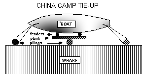
The waters offshore become shallow at low tide. If you tie up at the wharf, you must be away before the low tide grounds your boat. Near the end of the wharf, there is about one foot of water at a zero MLLW level. Tide levels are delayed about one hour from Golden Gate times.
Management
Tying up at and casting off from the wharf is a tricky business. If currents are strong, they will try to push you either away from or into the wharf, where you will be bumping and scraping against tarry pilings. You may decide to use either side of the wharf, depending on whether you expect stronger currents on entering or leaving. It is best to tie up as near the end as possible, where the water will be a little deeper. You will need to employ a method of tying up that will allow the boat to remain secure against the non-floating wharf while the tide level rises and falls, without messing up the boat sides and fenders with tar. One method that has worked successfully is to tie up a stout plank or post outside the fenders, which are hung in their normal positions at the winch and at the shrouds. The plank should be long enough so that its ends extend beyond the fenders at least a foot, so at least a 7 ft. plank is needed. The boat is positioned so that one piling butts against the plank at its center, while bow and stern lines are looped from their respective chocks to the next fore and aft pilings, and back to the chocks again. The loops should be tight enough to hold the boat securely against the middle piling, but loose enough to slide up and down the bow and stern pilings with the tide level. It is somewhat difficult to loop the bow and stern lines around the pilings, but the arrangement makes casting off very easy. This method has worked stably enough in the past to allow a Cal 25 to raft up against a Commander.

To set up the aforementioned, first approach the appropriate wharf ladder and disembark one of your crew with a temporary bow line, followed by a second crew with a temporary stern line. These persons will assist in moving the boat backward and forward as you attach the permanent bow and stern lines. Most of the rest of your able-bodied crew will assist in fending off from the wharf. It is usually easier to deploy the permanent bow and stern lines from the wharf, so this will involve a third person working dockside.
To cast off from this arrangement, first let off the stern line, while pulling the stern away from the dock with your motor (or the wind or current may be sufficient to drift you away, if in the favorable direction and strong enough). Be very explicit about telling your bow crewperson not to let the bow off until given definite word. When the stern is away enough, let the bow go, and motor back or drift it away further from the wharf, then motor or sail forward and out. The crew persons tending the dock lines should be warned to quickly gather in the line from the water, so that it does not trail behind and foul the motor propeller. Be careful not to drift too close to shore, if the tide level has lowered considerably.
The alternative to the above arrangement is to anchor out and dinghy in.
A cafe at the beach sells soft drinks, beer, sandwiches, shrimp cocktails, and other food items.
Point San Pablo
What's there
We stop in here at the little old isolated, quiet, picturesque, idyllic Pt. San Pablo Marina. The cafe here serves quite good, inexpensive food, and the proprietors need the business, so I highly advise eating here rather than picnicking. The hamburgers and lemonade are particularly recommended. After eating, we usually stroll out the railroad tracks past the former whale processing plant to the tip of Pt. San Pablo, for a close view of The Brothers lighthouse.
Cautions
Review the location of rocks, wrecks, and shallows before navigating the entrance channel.
In the spring, weather systems sometimes occur that produce strong northwest winds which develop a powerful momentum coming across San Pablo Bay. These will be predicted by the weather service. When these winds are blowing at 20 or 25 knots, they can make the departure out the marina extremely challenging. With your boat pitching in the heavy chop, it becomes difficult, if not impossible, to motor directly against the wind. Sailing is likewise difficult, because of the narrow channel. I have found it most expedient to use both motor and sail, using the motor to power and turn the boat through the short tacks. I cannot overemphasize the arduousness of this departure --a rather great physical demand is placed on the motor person to maintain footing against sharp heeling, while executing precision motor-assisted turns. The rest of your active crew will also find themselves tested. Don't enter Pt. San Pablo harbor if you don't think you will be able handle the sail outbound.
Management
We usually dock next to the gas dock, near the cafe, but it is also possible to dock at empty slips elsewhere in the marina. This dock is sometimes used by the lighthouse shore boat, so you should leave room here for it.
Point Richmond
This is rarely chosen as a club cruise destination because it involves a very short sail. At Brickyard Cove, the canals with waterfront condominiums are interesting to explore. It is possible to dock at the Richmond Yacht Club guest dock.
Petaluma River
What's there
This is an overnight cruise, not often done in recent years. Scott Hotes and I did this one in July of 1994. It's fun sailing up the river, through green or golden (depending on the season of the year) fields, and there are interesting sights along the way. A sail in the country! In the old days we used to stay overnight at the Lakeville Marina, where the food and hospitality had been good, but ownership has changed, and the bar/restaurant/dance club that was here has been converted into a family restaurant. The best bet nowadays is to go all the way to Petaluma, where there is a large municipal dock facility near the center of town. Petaluma abounds in restaurants and night life hangouts.
Cautions
Consult your chart for shallow areas on the river, especially Cloudy Bend, just below Petaluma. There used to be a very shallow spot south of the Petaluma draw bridge; I assume that it is still there. In Port Sonoma, the docks behind the gas dock are shallow, and you will run aground if you try to use them. It is usually fairly easy to get off the banks of the river if you run aground tacking, but if you cut inside the buoys at Cloudy Bend, you may be there many, many hours waiting for a high tide.
There is a drawbridge on the south side of Petaluma. You should give 4 hour advance notice of your intention to pass under it. The weekday phone number for the bridge is listed in most tide books, but tide books don't tell you that on weekends you need to call the Petaluma Police Department. The drawbridge can also be called on marine radio channel 9. They don't always monitor channel 16, anymore. The bridge raises hourly during the day on busy weekends, but they want you to call to let them know you are coming.
Management
Four people can sleep in the cabin of a Commander. It is also possible to rig a tarp across the boom, for shelter from the dew for a person sleeping on the cockpit sole. All persons will need sleeping bags. The dock at Petaluma is not convenient to sleep on; people walk by, etc. Bands at local night spots may play loud music, so you might want to bring good ear plugs.
Convenient rest stops along the way are Pt. San Pablo, China Camp, Port Sonoma, Mira Monte Marina (Now called Semper Marine? There was formerly a popular oyster bar here.), and Lakeville.
It takes about 9 hours to make your way to Petaluma, with a couple of 30 minute rest stops, but you may make better time with strong flood currents and west winds. The wind is usually from the north on the river, but on very lucky days you may have a west wind, or sometimes a south wind going part of the way up. If you return early on the morning of the next day, you will be unlikely to have any wind at first. On the way up, the river becomes too narrow to tack across as you get upstream, if your crew has not rebelled against manning the jib sheets before this. So expect to do lots of motoring, and bring plenty of gas. If you have insufficient gas, you can buy more at most of the stopping places along the way.
Planning currents for the cruise is difficult because you need a weekend with maximum hours of strong flood going up, but want as much ebb as possible going back. A flood current is vitally necessary to work your way up the river, which has a strong outflowing current. Note that the delay from Golden Gate time for the flood current will work in your favor on the way up, but not so for the ebb on the way back. One way of working with unfavorable currents on the return trip is to plan on a long rest stop somewhere on the way back to wait for strong opposing currents to subside.
Vallejo/Carquinez Strait/The Delta These would all be overnight or longer cruises, because of the distances involved. They are not often done nowadays, though in the past the club has had members who loved to cruise the Delta, and did it frequently, usually for a week or more at a time.
Charles Clausen 11/7/92
revised 9/15/93, 11/17/94
